
I am not sure how it started but I just realized one day that I was already on the verge of joining a unique hike in the highlands of Cebu. After reading some information on the Cebu Highlands Trail (CHT) shared by some of the community members of the Cebu Climbers' Community Facebook Group, I eventually found myself giving in to this challenge dubbed by Team Lakad Ninja as a dream climb. It all started with an invitation from one of the climbers who was looking for someone to complete the cohort of their CHT climb. Due to my sporadic work schedule and graduate school tasks, I often find it difficult to travel with a group especially on a planned trip. I usually hop on a random solo trip or a spur-of-the-moment escape with friends. However, it is different this time because I am committing my weekends to complete the Cebu Highlands Trail.
 |
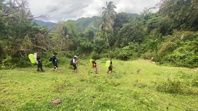
| Group photo with the Cebu Highlands Trail 2021 Cohort at the Mt. Manunggal trailhead |
A brainchild of Sir Jing, an outdoor educator, explorer, adventure guide, bushmaster, thru-hiker, and the blogger behind Warrior Pilgrimage by PinoyApache Blog, CHT is a span of more than 400 kilometers of trail traversing through the highland spine of Cebu province starting from Bato, Santander in the south to Maya, Daanbantayan in the north. According to Cebu Highland Trail Project's Facebook Page, it is patterned after the Appalachian Trail and the Pacific Crest Trail of the U.S.A. Similarly, CHT offers a magnificent view of the highlands of Cebu exposing some of its undiscovered trails and the rich culture of the local communities.
 |
| Image Source: Adrenaline Romance Blog |
While I find it stimulating to finish the CHT in one long hike which is, according to Sir Jing, doable in around 26 days, it will require more rigid physical and mental training and, of course, time. Traversing through CHT in segments is a better idea for me. Luckily, the team which I joined was planning to complete the CHT in segments which, in total, composed of eight segments with some long trails divided into subsegments.
Cebu Highlands Trail Segment 1A
Segment 1 is divided into two subsegments wherein each segment can be completed within two days and one night depending on one's pace. Segment 1A is a 32-km stretch of mixed trails starting from the peak of Mt. Manunggal in Balamban to Mt. Tungkay in Toledo City and ends in Barangay Bonbon in Cebu City. The majority of the trail is part of the Central Cebu Protected Landscape -- a protected area that encloses many of Cebu's endemic and indigenous species of flora and fauna.
While some of the trails are familiar especially for seasoned hikers in Cebu, one should not easily jump to the conclusion that this segment of the Cebu Highlands Trail can be traversed through unguided exploration. A handful of trails are not established and can be considered technical with some terrains characterized by loose surfaces, steep assaults and descents, mud, water, and knife-edge trails which require extra skills and guidance from someone who has a better familiarity with the place.
Day 1: June 5, 2021
After assembling at the Cebu IT Park, we left for Mt. Manunggal trailhead via van from the terminal fronting Ayala Central Bloc in Cebu IT Park. An hour and a half vehicle ride brought us to the trailhead where we had our quick briefing before heading to Mt. Manunggal Eco-Adventure Park which is the jump-off. We also had a short getting-to-know-each-other as some of us just met for the first time for this mission. During the briefing, Sir Jing emphasized that he will be guiding us through traditional navigation as he did not use any advanced technology in navigating through CHT and in mapping the routes. It means that we would be relying on his memory throughout the hike and the possibilities of getting lost along the trail were likely to happen. My craving for an adrenaline-pumping adventure was activated knowing that, somehow, we will be experiencing what Sir Jing experienced during his early explorations of the Cebu Highlands Trail.
 |
| Setting of expectations and brief orientation on the Cebu Highlands Trail with our guide and the man behind CHT, Sir Jing Lavilles De Egurrola |
After registering at Mt. Manunggal Eco-Adventure Park and doing routine muscle stretching, we immediately started the hike. At this point, the trail was still familiar since I have climbed Mt. Manunggal three times already one of which was a solo climb (vlog here). Having read the experiences of those who have tried hiking through the Cebu Highlands Trail, I knew I could not discount this new experience with my little familiarity with the trail. I knew that I was up for a different level of exploration and adventure.
 |
| Stretching before starting the hike to condition our muscles to the impact of the activities that we were about to undergo |
 |
| Mt. Manunggal is a historic mountain as it was the crash site of Mt. Pinatubo, a presidential plane carrying then-President Ramon Magsaysay along with twenty-five other staff. We stopped for a photo-op at the shed where Mt. Pinatubo's engine is exhibited. |
 |
| A short descent from the engine of Mt. Pinatubo, a memorial of Pres. Magsaysay was erected. This place is a popular campsite among climbers in the area. |
As expected, the familiar trail that I was referring to earlier was just a prelude to a more challenging thru-hike. In a matter of minutes, we started hiking through steep slopes and knife-edge trails hidden between tall grasses that could prick your skin if you are not wearing the right protective gear. We also went through unfamiliar terrains and slippery trails. Looking at our itinerary, I knew we were only an inch done with the entire segment and more adrenaline-pumping challenges were about to happen.

After around four kilometers of the hike, we reached a small community in Barangay Sunog, Balamban, and decided to take a couple of minutes to rest. The locals in the area were very welcoming and showed their hospitality by offering us some fresh coconut juice (buko) for free. However, we insisted to pay for what we had out of our appreciation and acknowledgment of their efforts to help us quench our thirst.

We were already behind our itinerary so we immediately headed to Lusaran River. Unfortunately, heavy rainfall forced us to stop by for shelter in an unfinished house near the river. This meant that we will not be able to reach our target to hit Barangay Inalad before lunch so we decided to use up our supply for breakfast the following day and just resupply in Inalad. It was a good decision because heavy rain continued to pour until we finished our meal. Keeping the situation worse, I suddenly felt a terrible headache on our way down to Lusaran River but I could not tell anyone about the situation considering that we just started our hike. I did not want to be a burden to the group and the reason for the deviation in the itinerary. Good thing, I was able to bring pain-relieving tablets. I just took two tablets and conditioned my mind that the situation would get better. I immediately felt relieved after a couple of minutes.

Due to the heavy rain, the water level in Lusaran River rose and the water current was strong. We had to cross the river arm to arm and face the current. It was already past two o'clock in the afternoon and we were already more than two hours behind our itinerary.


 |
| Crossing the river with Lakad, a trail dog that followed us from our jump-off in Mt. Manunggal until we finished the segment. Apparently, the name is derived from Team Lakad Ninja. |
After the rain, our hike was made more rewarding because of the magnificent view brought by the fogs that covered parts of the mountain ranges in Cebu City and Balamban. I consider it as one of the love-hate relationships in any nature hiking activity. More often the usual, your struggles are instantly soothed by the awe-inspiring views that nature never ceases to reveal.


Around four o'clock in the afternoon, we arrived in Barangay Inalad and we immediately replenished our supplies before heading to Barangay Tungkay in Toledo City. In our original itinerary, we were supposed to have our lunch here but due to the heavy rain, we had to make some sudden changes.

We arrived in Barangay Tungkay, Toledo City past five o'clock in the afternoon already and we waited for the Barangay Captain for a courtesy call before heading to the campsite in Mt. Tungkay. It is important that we inform the local chief about our presence in the area for our safety and to show respect and courtesy to the locals as well. Since these areas are not known camping spots and are not frequented by hikers and mountaineers, keeping the locals aware of our presence was of utmost importance for them not to doubt our presence in the area and our purpose.
After doing the courtesy call and securing water that we can use in cooking for our dinner at the campsite, we continued our hike to Mt. Tungkay. We had to cross another river before a continuous assault to the campsite. The assault was more challenging this time because of the loose surface caused by the rain.

While we never planned for a night trek in the itinerary, we were all ready with our headlamps in case of possible deviations and redirections. True enough, we had to do our first night trek to the campsite. Past seven o'clock in the evening, we were still looking for the campsite. Sir Jing was straightforward in setting proper expectations on the onset that we might lose our way because of the changes and developments in the area. At this point, the trail was also hardly visible because of the rain and fog.

After some attempts to look for the campsite, Sir Jing decided that we would just set up an emergency campsite as it was already getting late and the hike was already exhausting. True enough, the Cebu Highlands Trail offers a different level of hiking and backpacking experience. Going through the trail was not just a test of physical endurance but also a test of one's mental stamina to stay afloat amidst the adversities given the sporadic weather condition and other factors that were beyond our control.

Our emergency campsite was a slope with an inclination of around fifty degrees. Looking for a flat surface where we could pitch our tents was tantamount to finding a piece of needle in the middle of a huge crowd. Ideally, a bivouac would be a good alternative but I opted to look for a flatter surface for my tent. Luckily, I was able to clear a little space enough for half of my tent. I did not carefully install the pegs and rain fly anymore -- I just needed a small area where I could rest for just a few hours.

After pitching my tent, I did not think of having dinner anymore. Getting some rest after an exhausting but equally fulfilling journey was more important than having a meal. Before the hike, I imagined a good dinner and fellowship with the team over good food and some drinks but after the challenging traverse that was aggravated by heavy rain, I just wanted to slumber inside my tent and store some energy for the next day's hike. The rain continued to pour during the night and I felt that my tent was already moving downhill. I woke up the following day noticing that a side of my tent was soaked in water. Observing my tent from the outside, it was apparently deformed. Looking at the other tents, I knew I was not alone and I was pretty sure that everyone endured the same challenge over the night.

Experiencing a little portion of the first segment of the Cebu Highlands Trail for a day, I came to understand what Sir Jing meant when he said in his blog (Adrenaline Adventure Hike: Segment 1A) that Segment 1 is the most intimidating of all the eight segments. Although we divided the first segment into two, I knew that our experience during the first day was already a contributing factor to the intimidating nature of Segment 1. This experience should keep me going and expecting more not only during the course of this segment but for the rest of the CHT journey.
Day 2: June 6, 2021
The rain continued to pour on the second day and we started Day 2 preparing for our breakfast and lunch under the shade of a tarp that we set up. Grabbing some instant meal could have been an idea considering the terrain of our emergency campsite and the weather condition. However, there was no turning back this time. We had to pursue our meal plan and give ourselves a rewarding meal for finishing the first day and motivate ourselves for the day that will be.
 |
| Cooking for our breakfast and lunch amidst the rain on an inclined campsite. |
 |
| Pork sinigang for breakfast. Some of the ingredients were sourced out from the farms we passed by during the first day of our hike. |
 |
| We were supposed to cook this pork humba for dinner during Day 1 but everyone was so tired to prepare slow-cook meals. |
A little beyond nine o'clock in the morning, we left our emergency campsite and continued our trek to Maraag in Sudlon II, Cebu City. We headed back to our trail the other night to look for the way going to the original campsite then to Maraag. Like the trail during the other night, the way to Maraag is pretty technical traversing through knife-edge ridge from Mt. Tungkay to another range of mountain.

It was a relief to see our supposed campsite the other night. I wished we could stay a little bit longer in the area to, at least, feel the flatter ground on our back while resting but this area will remain the best campsite that we never had in this segment. It was rewarding to, at least, get a little rest here while appreciating the surrounding mountain views of Balamban, Toledo City, and Cebu City. The site also offered us a great opportunity to look back on how far we have gone in this segment and at the same time, a glimpse of the trail that we had to go through for the day.
 |
| Mt. Tungkay Campsite -- the campsite that we never had |
 |
| Traversing through knife-edge ridge to the next range from Mt. Tungkay to Maraag |
 |
| Christophine or pear squash (local name: Sayote) garden along the trail to Maraag in Sudlon II |
Thirty minutes before high noon, we arrived in Maraag. We had a quick stop at a small community to have some refreshments before heading to Panas. After treading through concrete roads in Maraag, we turned right to an unpaved road to Panas. Noticing a water source along the road, we decided to stop and have our lunch for an hour. We were becoming more comfortable with each other at this time so we had a good exchange of laughs and stories while enjoying the packed meal that we prepared at our campsite earlier. I was glad how open and cordial this group was. Despite the fact that I just met most of them in person for the first time, I easily became comfortable with their company.

After lunch, we had a short rest before we resumed our hike. I happened to have a random conversation with Sir Jing while resting and I was surprised how our paths have already crossed before. Around two years ago, I dropped by the anniversary exhibit of the Cebu Mountaineering Society at the Ayala Central Bloc in Cebu IT Park. At that time, I was looking for networks on mountaineering and outdoor activities to help me enrich our curriculum on Recreational Activities. Cebu City, being composed of relatively highland areas, should offer contextualized curriculum on outdoor ethics and safety. Little did I know that Sir Jing got the calling card that I left at the booth of Cebu Mountaineering Society. Although we were not able to connect due to the suspension of most of the outdoor activities during the heights of the COVID-19 pandemic, I was glad to have finally connected with Sir Jing and personally learned from him during this hike.

On to the trail, we passed by these wild raspberries growing at the sides. Locally known as Sampinit, these shrubs normally grow in areas with higher elevations. I heard of these berries abundant along the trails of Mt. Apo but I have to check yet. For now, it is rewarding to try these wild raspberries growing in the highlands of Cebu.

The way to Panas was covered with rewarding sceneries that leave a constant reminder of the beauty that this world offers and our enduring responsibility to take care of these natural wonders fur the future generation to enjoy.


We arrived in Panas around three o'clock in the afternoon already. We took a short rest while Sir Jing was deciding which way to go. As communicated to us by his assistant, Apol, we were considering diverting to another trail as the river trek might not be safe considering the incessant rain the previous day and the possibility of raining again as indicated in the weather forecast. In the end, we decided to head to Biasong Creek and do a river trek all the way to Barangay Bonbon.

Initially, the downhill trek to Biasong Creek was an awe-inspiring traverse. We were trekking in an enclave of greeneries brought forth by the tree-carpeted mountain ranges of Cebu City. The exquisite scenery was further evoked by the sea of vegetable gardens maintained by the local farmers in the community. The first time I explored the mountains of Cebu City, I was amazed to see a different side of the queen city of the south which is in perfect contrast to its busy streets and concrete parks. I could only hope that the city government will be able to conserve this place for future generations to also experience Cebu City on two contrasting sides.

The trail started to become so technical again as our exodus headed towards Biasong Creek. Like how we traversed through some parts of CHT in the earlier part of this segment, we were again left following a trail that was paved for us by Sir Jing. In several parts of this journey, I felt like I was following Moses (in the person of Sir Jing) who was leading us to the promised land. I had to let my feet and sometimes half of my body slip through the slope allowing me to earn the title daro (plower) boy throughout the hike.

Apart from sliding through the slope, there were also instances that we had to rappel using roots and vines that we could get hold of. Sometimes, we just grabbed hold of whatever shrub or grass that we see along the trail.

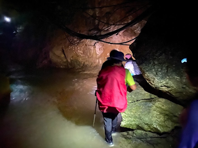
At five o'clock, we reached Biasong Creek and we were all ready with our headlamps because we were anticipating a night river trek to Barangay Bonbon. The river was so enticing for a dip and as much as we wanted to take some moments to enjoy the cool water, we could not do as much because we were racing against time.

As much as we wanted to evade the water to avoid soaking our footwear, we were left with no choice but to immerse our feet as the water level was higher than usual.

At times, we had to brave through the water current in crossing from one side of the river to the other in the search of a drier trail. Advised by Sir Jing to face the current when crossing, one of my comrades commented, "Water current is is just like a problem. We have to face it." Indeed, such a life cliché stood true in this journey. We had to face every challenge that came along the way in our pursuit for a life-changing adventure.


As we continued to walk along the river trail, we later realized that the light coming from our headlamps was slowly replacing the sunlight. The trail was hardly visible that we missed the detour from the impassable part of the river. While we were resting on a huge rock at the side of the river, Sir Jing went back to our way to find the trail leading to the detour. My admiration of the navigation skills of Sir Jing soared higher this time as I witnessed him again calmly and silently finding his way out of the enclave we were in relying only on his memory.

After a couple of minutes, Sir Jing came back to lead us back to the detour. I honestly thought that such a trail will bring us to the tail of this segment but it just brought us to the lower stream of the river where another long hike was about to happen. It was already past seven o'clock in the evening yet no signs of a nearby community were visible. We ran out of supplies so laying an emergency camp should not be a good option this time. At the onset of this segment, Sir Jing and Apol emphasized that the Cebu Highlands Trail requires a different mindset. Although my personal mantra is to always go with the flow and to always see the brighter side of the situation, I started to doubt if I could possibly make it to work the following day. At the back of my mind, I had to make myself ready for anything the could rise from the situation we were in and I already started to think of backup plans for the following day.
 |
| Night trek at Biasong Creek was not part of the itinerary but the setbacks called for it. |

We arrived in Bonbon around nine o'clock in the evening already. Hitting Lava Mountain Resort which signaled that we were approaching the tail of this segment, we were welcomed by the lights that illuminate through the river guiding us to a small community where we could finally say that we made it safe and sound.

Before heading back to JY Square in Cebu City, we had a group photo with Sir Jing. He also gave each one of us Cebu Highlands Trail and Warrior Pilgrimage stickers which I considered as a redemption of our tired mind and body.

Just when I thought that we were already done for this segment, another challenge came in -- we had a hard time looking for motorcycles (habal-habal) that could transport us back to the city. We ended up negotiating for a multicab that could bring us back to JY Square in Cebu City. Like how we keep some stories to ourselves to maintain the mystery and, maybe, for us to tell others in a more personal encounter, I will keep the remaining events after that multicab ride to myself and the others who witnessed. Nevertheless, the said experience left an indelible mark that will be forever etched in those wits and spirits that always cry for a near-death experience in order to stay alive.
I started this trail with some specs of doubt if I could make it. Moreso, some doubts about the decision I made to be with a group of strangers in the middle of this wilderness. But as I ended the segment, I did not only discover part of the Cebu Highlands Trail -- I also discovered part of the lives of these people I considered as strangers at the onset. In this segment, I did not only unearth new mountains and trails -- I opened a new level of experience in the outdoors that only Cebu Highlands Trail and good company could offer. I am tremendously grateful to Sir Jing and his assistant, Apol, as well as the rest of the people whom I had the chance to walk with throughout this journey.


